Armenians in Turkmenistan

The Google Map shows known Armenian communities in the Central Asian Republic of Turkmenistan. This corrupt and repressive state was ruled by the vainglorious dictator Saparmurat Niyazov from the break-up of the Soviet Union until his death in 2005 and since then by another narcissistic autocrat, Gurbanguly Berdimuhamedow.

There are perhaps 30 to 40,000 Armenians in the country, living mostly in the major cities indicated on the map. Armenians arrived in Turkmenistan during Imperial Russian times, others during the Soviet era. More recently, more arrived following the dissolution of the Soviet Union and the conflict between Armenia and Azerbaijan. Minorities have limited rights in Turkmenistan and, as might be expected, many Armenians with the means to do so have emigrated to Armenia, Russia or USA in recent years .

There is no registered Armenian place of worship in Turkmenistan. The state recognises only Islam and the Russian Orthodox Church (the churches of which are used by some Armenians).

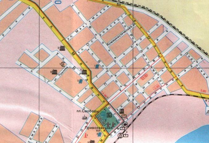
Of the five pre-Soviet-era Armenian churches (one per city shown on the map, except Balkanabat), the last standing was the one in Türkmenbaşy (Turkmenbashi – Russian Krasnovodsk), which was demolished in 2005. The former Armenian Apostolic church here was founded in 1904 but seized by the militantly atheist Soviet authorities in the 1920s and used as a warehouse. According to accounts on the internet, the church stood, decommissioned, at the junction of Pushkin and Lermontov streets. Street names in Türkmenbaşy have, for the most part, been renamed, although the street name Puşkin Köçesi survives in the old town (which was primarily Russian). However, Soviet-era Russian language maps do not show Ulitsa Pushkina and Ulitsa Lermontova as intersecting. Ulitsa Pushkina street was a short road joining Ulitsa Gogolya and Ulitsa Budennogo, both of which ran down to the square Ploshchad Privokzalnaya and the railway station by the waterfront. Ulitsa Lermontova, on the other hand, was further north, beyond the Russian cemetery (in which Armenians were presumably buried, it being the only Christian burial ground in the city) and running off 1 Maya (now Azadi Köçesi). Perhaps, therefore, Gogol rather than Lermontov was meant. Accordingly, the pin on the Google Map has been placed where the former Ulitsa Gogolya (now called Adalat Köçesi) joins Ulitsa Pushkina. In any event, the church survived until 2005, when it was demolished by the Turkmen authorities, despite repeated requests for it to be returned to the Armenian community.

The Krasnovodsk street plan below shows the old Russian town, with Russian street names, during Soviet times. Ulitsa Pushkina can be seen (as “ул. Пушкина”) towards the left-hand side of the map.


Krasnovodsk


The Urum Greeks of Tsalka, Georgia

The Google Map shows the former communities of the Urum Greeks of the Tsalka area of Kvemo Kartli in Georgia. This people is known as the Tsalkalides (in the Greek language) or Urumlar (in Turkish). Given that the Urum Greeks were and are Turkish-speaking, the latter name is probably more appropriate. The community is Greek Orthodox and identifies with the Greek ethnos even when not Grecophone.

The settlements shown on the map are those of the community’s heyday. It emerged by immigration in 1829/1830 following the withdrawal of Russian troops from eastern Anatolia after the Russo-Turkish War of 1828/29, when Christians feared reprisals and were granted permission to settle in Georgia (and elsewhere). It grew throughout the C19th and into the C20th. However, it is now sadly depleted by emigration to Greece and Russia.

The Urum Greeks’ neighbours tended to be Armenians, Azerbaijanis and Kurds for the most part, rather than Georgians; there were also Jews and Roma in this district.

In addition to the large number of villages around Tsalka, the map also shows a few communities slightly further afield, such as the former mining village of Opreti to the south and the cluster of villages around Jigrasheni to the east.

Place names given are the current official Georgian name (in transliteration, of course), followed by alternative names used by the Urumlar and others.

For further information, we recommend the Greek- and Russian-language website papounidis.com.


The Kurds of Red Kurdistan & Nakhichevan

The Google Map shows (with red pins) some of the more notable places in which Kurds lived during the short-lived “Red Kurdistan” of 1923-1929 and, of course, both long before and after. The Kurds of this area, approximating to the Lachin corridor and its extensions north and south, were notable for being Shiites (rather than Sunni Muslims). Over time, they started to assimilate into the Azerbaijani population and speak Azerbaijani rather than Kurmanji (only 8.3% of Kurds were recorded as Kurmanji speakers at the time of the Soviet census of 1926).

Most of the Kurdish communities became unfortunate collateral damage during the Azerbaijani-Armenian conflict of the early 1990s and many of the villages were completely destroyed by the Armenians – only the shells of buildings can be seen in satellite imagery. The local Kurds were internally displaced to Baku, Ağcabädi and elsewhere within Azerbaijan.

The map also shows (with green pins) the smaller number of Kurdish communities in the Azerbaijani exclave of Nakhichevan.


The Terek Kumyks

The Google Map shows the main locations of the Terek Kumyks in modern times.

Settlements in Chechnya are shown with green pins, those in Ingushetia are marked with red pins, and those in North Osseta-Alania with blue pins.

Germenchuk and Shali, in Chechnya, which lie away from the Terek river, are thought to be two of the sources of the Terek settlements. A few hundred Kumyks still reside in the town of Shali but Germenchuk now has an entirely Chechen population.

Kumyk place names are shown in brackets after the official (modern) Russian place names. For example, Predgornoye is known to Kumyks as Borasuv-otar.


The Udi

The Google Map shows the distribution of the Udi, an ancient relict ethnos of the Caucasus, the survivors of the formerly great Caucasian Albanian people.

Today, this Christian people is found primarily in two large villages in Azerbaijan (Nic and Oğuz, known until 1991 as Vartashen) and one small settlement in Georgia (Zinobiani). There are smaller numbers of Udi in a few other villages in Azerbaijan (and of course in its capital Baku) but most have assimilated or left the country for Armenia and, more especially, Russia. Most of the settlements in Azerbaijan marked with blue pins on the map therefore effectively show former rather than extant Udi communities.

As mentioned, there are numbers of Udi in diaspora dispersed across both cities and villages in southern Russia (shown with grey pins on the map) and elsewhere across Russia (not marked on the map).

Finally, there are also about 200 Udi refugees from Oğuz in a handful of villages in Armenia; these are marked with red pins.


The Tsakhur of Dagestan & Azerbaijan

The Google Map shows the main areas of settlement of the Tsakhurs. The Tsakhur are a northern Caucasian people or ethnos with their own Tsakhur language (one of the Lezgic family of languages in the NE Caucasus). The Tsakhurs will, of course, additionally speak the majority language, such as Azerbaijani or Russian, where they live. They profess Sunni Islam.

The Tsakhur territory was centred originally on a highland valley (that of the river Samur) in what is now the SW of the Republic of Dagestan in Russia. This is shown on the map by the line of 13 auls marked with blue pins. However, there was an expansion of territory over the mountains, extending it into what is now Azerbaijan, in the C15th – shown with green pins. The two capitals, as it were, were respectively Tsakhur aul itself in Dagestan, and İlisu village in Azerbaijan.

Place names on the Google Map are given in a standardised transliteration from the Russian for Dagestan, and in a modified Azerbaijani (using an ä instead of a schwa) for those in Azerbaijan. In some cases, alternative spellings or names are given in brackets.

One interesting place is Baş Suvagil, on the banks of the Qaraçay, which was flooded repeatedly, leading its inhabitants to establish a new Yeni Suvagil at a safer spot down on the plains. Satellite imagery suggests that people have again settled the site of Baş Suvagil.

The map also shows more recent dispersal by the Tsakhurs to the big cities of Dagestan and to a belt of Soviet era farming villages in the NE of the Republic.


Armenians in Uzbekistan

This Google Map shows the main Armenian communities in C20th Uzbekistan. Some of these, such as those in the old Silk Road trading centres, are long-standing, although until the late C19th they were very modest in scale (probably under 250 individuals each).

It is likely that Armenians, who are thought to number over 45,000 across the country, are also resident in many other towns in Uzbekistan not shown on the map.

The only two functioning Armenian Apostolic churches are those in the big cities of Samarkand and Tashkent. The Soviets in Central Asia were militant atheists and the other known Armenian churches were closed by the authorities during the 1920s and 1930s. It is likely that the largest Uzbek Armenian communities outside Samarkand and Tashkent will apply to raise places of worship in the next few years with the resurgence of interest in Armenian culture and the Church.

The local Armenians speak Russian and Uzbek. The longest-settled families speak Uzbek as opposed to Armenian and are well assimilated into Uzbek society. More recent immigrants from, for example, Artsakh (Nagorno-Karabakh) and Azerbaijan, are likely to have Armenian as their mother tongue.


The Mamkhegh of Adygea

The Google Map shows only a little of the history of the Mamkhegh. The Mamkhegh are a Circassian people and specifically one of the 12 Adyghe tribes, with their own eponymous dialect. They are Sunni Muslim.

Their historic villages were situated to the south of the town of Maykop. The approximate sites of the 12 largest of these are shown with blue question marks on the map. The exact sites are not certain but the distribution and spatial inter-relationship of them on the map is reasonably correct – or, at least, it follows the rough sketch map drawn up by local ethnographer Aleksandr Nikolayevich Dyachkov-Tarasov in 1901. Dyachkov-Tarasov uses the traditional Circassian and Caucasian word “aul” for each village and shows the borders of the Mamkhegh territory stretching south of Maykop in a dewdrop shape between Dagestanskaya and Abadzekhskaya villages on the rivers Kurdzhips and Belaya respectively.

These native villages were depopulated towards the end of the Caucasian War, circa 1862-63. At that time, most Mamkheghs, along with other Muslim Circassians, were deported from the Russian to the Ottoman Empire – presumably, their descendants live somewhere in Anatolia now. Those Mamkhegs who remained within Adygea were settled in the new eponymous village of Mamkheg and the other villages shown in yellow on the map.


The Archi of Dagestan

This Google Map shows the traditional villages of the Archi ethnos or people in the Republic of Dagestan, Russia.

The Archintsy, who are Sunni Muslim, speak their own Archi language (a peripheral branch of the Lezgic group of Caucasian languages) and self-identify (apparently mistakenly, given their language) as Avars.

The Archi are usually described in internet sources as occupying eight villages, although all the accounts, at least in the English and Russian languages, then proceed to name a maxmum of seven. Only seven villages are visible on satellite imagery, including that of Bing Maps (which is often superior to Google Maps and its derivatives for the mountainous Caucasus region). The identity of the eighth village is unknown; it is neither Chitab nor Shalib, which are situate to the N and NE respectively of the Archi villages, and there are no evident settlements to the S. Only seven are marked on this Google Map therefore. Possibly the eighth village was very small and has been abandoned.


The Khvarshi of Dagestan

This Google Map shows the distribution of another minority ethnos or people of the Caucasus, namely that of the Khvarshi (or Khwarshi) of the Republic of Dagestan in Russia.

The seven historic villages of the Khvarshi are shown with green pins on the map. The Khvarshi speak their own eponymous Khvarshi language and profess the Sunni form of Islam.

In 1944, the community was deported en masse from their traditional villages to Ritlyab (in Dagestan) and Vedeno (in Chechnya), places shown with grey pins on the map.

After the Great Patriotic War, many Khvarshi returned to their native villages in the highlands. Others remained where they were or moved on to the five settlements in northern Dagestan shown with blue pins on the map, where they remain till today.