The Digor Ossetians

This Google Map focuses on the Digors, Ossetians speaking the Digor (as opposed to the dominant Iron) language of North Ossetia. Under the influence of their western neighbours the Kabardians, many Digors converted, from either their traditional animist religion or from Eastern Orthodoxy, to Sunni Islam. It was this conversion which led to their oppression. The expansion of the Russian Empire into the Caucasus and the ensuing Caucasian War culminated in many Muslim peoples of the North Caucasus being ethnically cleansed and fleeing to the Ottoman Empire as muhajirs (emigrants, refugees) in the 1860s. Digor Ossetians were among them. During and immediately after WW2 (known to the Russians as the Great Patriotic War), Digors were one ethnos among many deported en masse by the Soviets to Kazakhstan. The majority, albeit not all, of the groups deported from the North Caucasus were Muslim (exceptions included the Black Sea Greeks).

The map shows past and present settlements of the Digors, both in North Ossetia (blue pins) and in Turkey (red pins). I should stress that the settlements shown in Turkey are believed to be Digor (rather than Iron) Ossetians, as it was the Digors rather than the Irons who converted to Sunni Islam and therefore were minded to seek refuge in or emigrate to Sunni Turkey in the 1860s. However, it is possible that some of the Ossetian communities in Turkey shown on the Google Map were in fact settled by Iron converts to Islam among the muhajirs from the North Caucasus; therefore, caveat emptor.

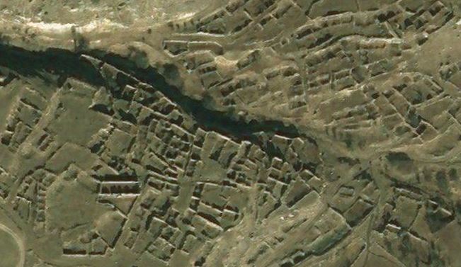
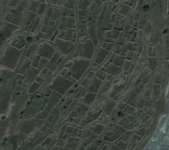
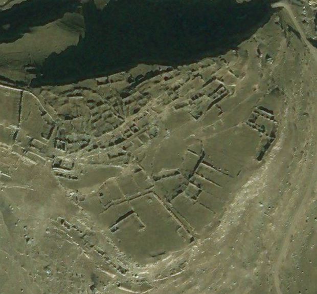
In the Digors’ traditional North Ossetian homeland, former settlements abandoned and destroyed are shown by the circular blue markers with the white x. In the pin texts, these are described as villages but most were very small settlements and some were inhabited by a single extended family.

The exact location of the abandoned settlements is not always clear. In some cases, satellite imagery shows clearly the outline of buildings (surviving stonework etc), presumably of villages abandoned in the C20th. In other cases, there is no immediately obvious trace at the available map coordinates, while in others the current sateliite imagery (as at January 2018) does not permit any inspection due to thick cloud cover.

Please note that the map excludes the cities to which Digors have moved as economic migrants – for example, Moscow and St Petersburg in Russia and Ankara, Istanbul and Sivas in Turkey. Digors also reside in diaspora in, for example, Kazakhstan (descendants of the deportees who have not returned) and Syria.


Return to Lithuania, 1921

In eastern Europe, the aftermath of the First World War and the Russian Revolution was chaos and population displacement on a previously unknown scale. Imperial Russia unravelled around the edges and new states struggled to assert their independence and pull away. In the former Russian gubernias of Kovno, Vilna and Grodno, moves were afoot to recreate Lithuania.

However, the issue here, as elsewhere in Europe, was that there were competing and mutually incompatible claims to land. It was impossible to satisfy all claims, as the population was not neatly parcelled up into ethnically or nationally homogeneous units. Most regions had diverse populations. In the city today called Vilnius, for example, Poles and Jews formed the majority and in its hinterland many of the pre-War landowners were minor Polish gentry or szlachta; yet the peasantry was Lithuanian. Force decided the issue and treaties ratified it. It was the new Polish state which emerged victorious, securing a Polish Wilno, just as it successfully secured Lwów as a Polish island in a largely Ukrainian sea.

At the start of 1918, as many as one in six Lithuanians were refugees within Russia. An estimated 550,000 were scattered across European Russia, from Minsk and St Petersburg to distant Voronezh and Yekaterinoslav. It took until 1924 to bring home all those who wanted to return and who Moscow and Kaunas would between them allow. Maybe as many as one third of Lithuanian refugees remained abroad and settled, willingly or otherwise, in Soviet Russia or Poland.

From 1921, the return of refugees was closely supervised by the authorities. Refugees were registered and issued with travel permits in Moscow. From Moscow they travelled by train to Rēzekne, Daugavpils and Kalkūni in Latvia, and thence across the Lithuanian border to Obeliai. At Obeliai – the only recognised point of entry into the country, although not the only one in practice – refugees were vetted, re-registered and issued with passes, usually to their place of birth or pre-War residence.

Those who were regarded as suspect were sent back to Moscow. And those refugees who wished to return to their pre-War homes in what had become Polish territory were often stuck in limbo for months on end in the Obeliai transfer camp, with its ever-present risk of humanitarian crisis – typhus, cholera and hunger.

Not all those coming to Lithuania were refugees. So-called optants – Lithuanian colonists long settled in Russia – paid their own way to reach the newly independent country. And from 1918 to 1921, the nascent Lithuanian state, in need of qualified administrative and technical experts, welcomed back not just its Lithuanian but also its Jewish middle classes. In fact, the immigration policy was so liberal before the change of government in 1922 that Jewish doctors, engineers and so on from elsewhere in Russia headed to Lithuania for the opportunities it presented.

For many researching their family history in Lithuania, the period 1915 to 1924 looms like something of a black hole. For a start, the family may not appear in the expected parish registers (assuming, that is, that such records were created and have survived). Over half a million spent several years effectively in exile in Russia and, of course, of these, some married, some had children and some died there. At Obeliai, too, refugees gave birth or died and, doubtless, in some cases married. The Lithuanian state did not recognise Soviet civil registry marriages so, in order to return with spouse and children, natives of Lithuania would have to remarry in a Roman Catholic or Orthodox ceremony: this can result in what appear to be illegitimate children born between the respective dates of the secular and the religious marriage.

The Google Map shows the railway route from Moscow’s Vindavsky Station to the transfer camp at Obeliai.


The Abayudaya of Uganda

This Google Map shows the distribution in Uganda of the communities of Abayudaya, who are C20th converts to Judaism.

Their story can be read about in a chapter in James R Ross’s book “Fragile Branches: Travels Through the Jewish Diaspora” (although strictly speaking, of course, the Abayudaya are not diaspora Jews), published in 2000 by Riverhead, which is an enjoyable and easy read. There is also an informative and up-to-date Wikipedia page on the Abayudaya which develops their fascinating and still evolving story. The Abayudaya appear to be a surprising success story: a confident, expanding community with a clear sense of purpose and now enjoying a degree of support from and recognition by Jews in USA and Israel. Indeed, they now receive mention as a tourist attraction in Uganda (a kind of ethnographic curiosity) which, however uncomfortable as a concept, has probably been important in raising funds for development and, significantly, in commanding acceptance and respect from their Christian and Muslim neighbours.

All the known Abayudaya communities are marked on the map in correct or approximately correct locations, even those which are the smallest often scattered settlements within the parish units which make up the administrative geography of Uganda. Where a precise location of a synagogue or community school was found, the pin is placed upon it. Where that wasn’t the case, the marker pin has simply been placed towards the centre of the village or parish.


אבאיודאיה

The Jews of Libya

This Google Map is the fourth in a series showing the former and, in some cases, current Jewish communities across the Maghreb, from Morocco, through Algeria and Tunisia to Libya.

It shows the former Jewish communities in Libya. It is thought that no Jews remain in the country today. However, there were once as many as 44 synagogues in the capital Tripoli alone. This city had a thriving Jewish community (approximately 20% to 25% of the city’s population), concentrated in the old town Hara district – this is the neighbourhood in which the still standing but sadly derelict Dar Bishi or Dar al-Bishi synagogue is marked on the map. However, a good deal of Jewish heritage in Libya has been purposely erased, much in the recent past. The Jewish cemetery in Tripoli was deliberately destroyed to make way for development – the Corinthia Hotel, opened in 2003, now stands on its site. The Bu-Shaif (or Slat Abn Shaif) synagogue in Zliten was also destroyed at about the same time to make way for an apartment block.

Most Jews in Libya resided in towns along the Mediterranean seaboard, the majority in Tripoli. Blue pins on the Google Map are settlements in the historic region of Tripolitania in the west of the country, while green pins mark those Jewish communities in the region of Cyrenaica in the east.

The red pins show Jewish places of settlement in the Jabul Nafusa (the Nafusa Mountains). These are the Berber highlands where, as in Morocco and Algeria, Jews lived alongside the indigenous Berbers and spoke their language (Amazigh). Although as many as possible have been abstracted from sources, it is certain that there were additional, smaller Jewish communities in Nafusa which are not shown on this map, particularly around Yefren (Yafran). In Yefren itself, and to its NE between the hamlets of Qaryat al Maanin and Al Qusayr, are two of the seven Ghriba synagogues of the Maghreb. The word Ghriba means “strange and wondrous” in Arabic, and the Ghriba synagogues are places of pilgrimage to Maghrebi Jews. The most famous is, of course, the Ghriba synagogue on the island of Djerba off the coast of Tunisia. All seven of the Ghriba synagogues are marked on bluebirdmaps’ Maghrebi Jewish Google Maps for Algeria  (see pins for Annaba and Biskra),  Tunisia (see pins for Ariana, El Kef and Hara Sghira) and Libya (pins for Qaryat al Maanin and Yefren).


Gli ebrei della Libia   יהודי לוב

The Chechens in Turkey

The Google Map shows only Chechen villages and not other centres of Chechen population in Turkey. For instance, there are many Chechens in cities such as Istanbul, Kayseri and Sivas – these are not marked on the map.

The Chechens in the big cities have mostly arrived as a consequence of the recent conflicts of 1994-1996 and 1999-2009, in which the Russian state has tried repeatedly and violently to crush Chechen nationalism. Chechens have been displaced across Europe as well as Russia and Turkey and a significant percentage of the total Chechen population now lives in diaspora.

However, a proportion of the city-dwellers in Turkey are migrants from the villages which are the main subject of the map.

The Chechen villages in Turkey date from the C19th (many from the 1860s) and were settled by refugees – generally known as muhajir or muhacir – from the Russian conquest of the north Caucasus (the Caucasian War). The villages are mostly small (with typical populations of 100 to 300 persons), traditional and agricultural, with only basic facilities. This is the background to the rural-to-urban drift, as the younger generation is pulled out of the native communities by economic want and lack of opportunity. The villagers are Chechen-speaking as well as being Turkophone (schooling in Turkey being in Turkish) and, of course, are Sunni Muslim.


The Jews of Tunisia

This Google Map is the third in a series covering Jewish communities in the Maghreb. It maps the places in Tunisia in which there were, and in some cases still are, Jewish communities.

As with the companion maps showing Jewish settlement in Morocco and Algeria, this map does not claim to be complete and comprehensive. However, it is believed to show the location of all the major Jewish communities in Tunisia in the C19th and C20th. Of these, very few now remain, other than the two communities on Djerba and those in the capital Tunis and a few towns such as Zarzis.

As with the companion maps for Algeria and Morocco, the places are listed A-Z using the Latin alphabet. In many cases, there will be variant spellings, due to transliteration from the Arabic language original, so if you do not find a place of interest by searching, try scrolling down the A-Z list. In some instances, there are alternative and now defunct place names dating to the French colonial era (shown in brackets). Where there is a surviving synagogue, it is marked with a star of David. Where there is a Jewish  cemetery, the pin for the community is placed upon the cemetery (with text to this effect). If the location of synagogue or cemetery is not known, the pin for a community is simply dropped randomly in the town or village.

In the case of the capital Tunis, a number of municipalities which are part of the conurbation are shown under their own names – for example, Ariana, La Goulette and La Marsa. The main Jewish neighbourhood in the old town of Tunis is Hara (or El Hara), now usually known as El Hafsia; its synagogue is marked on the map.


Les Juifs de Tunisie   יהודי תוניסיה

Upper Balkaria

If you zoom in to Verkhnyaya Balkariya using satellite imagery on Google Maps or Bing, you notice, like a palimpsest, the history of past settlement around the modern planned town with its regular and rectilinear grid-like layout. As at the time of writing (January 2018), the Microsoft satellite imagery used by Bing is clearer than Google’s as it was taken in good light. Below are screenshots showing five of the vanished villages and hamlets of Upper Balkaria.

Glashevo:

Glashevo

Kospart:

Kospart

Kyunlyum:

Kyunlyum

Mukush:

Mukush

Sauty:

Sauty

The accompanying Google Map shows the main villages (blue pins) and various hamlets and neighbourhoods (grey pins) of this part of the Cherek river valley in Upper Balkaria. Until Nov-Dec 1942, these were entirely populated by Balkars, a Turkic and Muslim people of the north Caucasus. At that date, these Balkar villages were razed and the population decimated – men, women and children were brutally killed by the Red Army on the orders of the NKVD. As you can see from the images above, the villages were completely destroyed and only a ruined archaeology remains.

In March 1944 the balance of the inhabitants of Upper Balkaria, together with all other Balkarians (37,103 in total, according to NKVD head Lavrentiy Pavlovich Beria’s official report), was deported en masse to Central Asia (mostly the Kazakh and Kyrghyz Soviet Socialist Republics). There they remained in exile until a decree of March 1957 permitted the survivors to return to their homeland.

According to the 2010 census, Balkars make up  12.7% of the population of the Russian Republic of Kabardino-Balkaria (being outnumbered by the indigenous Kabarday, who comprise 57%, but also by ethnic Russians, who make up 22%).


The Jews of Algeria

This Google Map shows the principal former Jewish settlements of Algeria. As may be expected, these are concentrated along the Mediterranean coastline and its hinterland but there were significant communities in fertile oases and trading posts in the Sahara.

Of particular interest is the former Jewish population of the so-called pentapolis of the M’zab valley, comprising the ksar (walled town) of Ghardaïa and its four neighbours. The Mzabite (or Mozabite) Jews of Ghardaïa numbered approximately 6,000 at the time of Algerian independence in 1962 but they and their descendants now live in diaspora in France (Paris, Strasbourg) and of course Israel. However, their synagogue survives in the old Jewish quarter of Ghardaïa.

There are presently no functioning synagogues in Algeria. Many were converted into mosques and a few of these are indicated on the map with stars of David despite their current status. Other synagogues are either disused and derelict (as in the case of Ghardaïa) or have been put to temporal purpose.

There are many surviving Jewish cemeteries in Algeria. Where these were identifiable on maps, in the absence of a synagogue building, the pin for the former Jewish community has been placed upon the cemetery.

The map is not necessarily fully comprehensive but is believed to show all the main Jewish communities across the country.


Les Juifs d’Algérie | יהודי אלג’יריה

The Circassians in Israel, Jordan & Syria

This Google Map shows present and former Circassian settlements in the State of Israel (green pins), the contested Golan Heights (the 14 red pins), Syria (blue pins) and Jordan (yellow pins).

The Circassian villages in the Israeli-occupied Golan Heights were abandoned and destroyed during or after the Six Day War of June 1967. They are shown by the eight red pins with a white x. Those Circassian villages in Golan outside the Israeli zone, within the Quneitra Governorate of Syria, appear still to be intact. The two main Circassian settlements in the Syrian Golan are Beer Ajam and Bariqa, but many from these villages, and the Golan generally, were internally displaced and moved to Aleppo and Rukn al-Din in Damascus (not marked on the map).

The Circassians have lived in this region of the Middle-East since the Circassian Genocide of 1864, when a majority of the nation fled the Russian forces and escaped by boat across the Black Sea to ports from Varna in the west to Trabzon in the east. Those who survived the voyage and its immediate aftermath as refugees on the Black Sea coast, where they suffered from exposure, hunger and disease, eventually resettled in a number of areas within the Ottoman Empire. One of these is the line of settlement that can be seen on the map, extending from Manbij in Syria in the north to Kfar Kama in Israel and the cluster of communities in Jordan to the south.

In the case of the two Circassian villages in Israel, a number of features are marked on the map – mosques, cemeteries, cultural centres etc.

There are, or were, also Circassians in Raqqa and the Circassian mosque in their Al-Sharaqsa neighbourhood was used by Islamic State for sermons and decrees. The mosque has been largely destroyed in the recent conflict but the minaret, although damaged, still stands (as at December 2017).


The Jews of Morocco

This Google Map shows the once very widespread settlement of Jews in Morocco. Stars of David on the map show synagogues; regular pins show Jewish cemeteries, pilgrimage sites (hiloulot) and former communities from the C19th and up to the exodus during the third quarter of the C20th (which peaked in 1948, 1956 and 1967).

The map shows the main centres of population but does not claim to be complete – there were many more small Jewish communities, especially in the Berber villages in the mountains.

The Jewish population of Morocco was made up of three main components. There were the Toshavim, or indigenous Maghrebi Jews – those who were already present in the country before the arrival of the Gorashim, being the Sephardim who were expelled from Spain in 1492. Finally, the Ashkenazim arrived later and settled in the bigger cities and ports. The Jewry of Morocco was therefore characterised by significant internal cultural differences and traditions, with (for instance) some Sephardic Jews regarding the religious practices of the autochthonous Berber Jews as unorthodox and irregular (containing, as they did, folk and syncretic elements).

In the urban environment, the Jewish quarter of a town was known as the mellah: typically, gated and contained within its own walls, and characterised by very narrow pedestrian alleyways. Sometimes, by extension, the word mellah was used figuratively for the Jewish community of a particular place. Note that the words kasbah and medina have no specifically Jewish connotation; both refer merely to the old quarter of a town, with the former term traditionally implying fortification.

In the rural environment – in the interior and the Berber villages – there was not a mellah per se, but Jews tended to live in separate and discrete quarters of settlements adajacent but apart. In this context, the word ksar signifies a fortified walled village.

Many place names in the interior of Morocco are not distinct and unique, and can be transliterated into the Latin alphabet in different ways. However, it is believed that, where two or more candidates exist for a particular place, the correct one has been plotted on the map (any errors identified may be reported using the Contact form and will be rectified). Some place names are tribal or patronymic, for example those prefaced with aït or ouled (both of which mean “sons of”), while others refer to distinctive geographical features, such as ighil (hill) and oued (wadi). Note that the etymology of place names may be either Arabic or the Tamazight (or Amazigh) of the native Berbers.


Les Juifs du Maroc | יהודי מרוקו