The Jews of Yemen

From mid-June to mid-July 1918, the British Army was actively recruiting in Jerusalem for “short service” (duration of war). Men were invited to enlist in the 40th Bn of the Royal Fusiliers. The new recruits were given army service numbers between J/4883 and J/5274 (and possibly a little either side of this regimental number range), suggesting that about 400 men enlisted in total. The great majority of these, and those recruited elsewhere by the 38th-40th Battalions of the RF, were of course Jewish, giving rise to the jocular Army nickname of the Royal Jusiliers.

Among the newly enlisted men were numbers who stated that they had been born in “Teman” – in other words Yemenite Jews. British rule in Palestine had encouraged a first wave of Yemeni Jews to emigrate from Yemen in the 1890s and 1900s; mostly they settled in Jerusalem and Jaffa. The RF recruits of 1918 had an average age of 27 years and were working men – a labourer, builders, a mason, a butcher, two janitors at the Tachkemoni School, a cigarette maker, a couple of manuscript writers, and many silversmiths and filigree workers. The silversmiths were from the Bukharim quarter, from Sukkat Shalom, from Mishkanoth, from Nahalat Tzedek and especially from Nahalat Zvi. For example, on 24 June 1918, the silversmiths Abraham Levy, Abraham Gershi and Elijah Rachabi enlisted; on 27 June, silversmiths Joseph Arussi and Chaiyim Levy attested. All five came from the Nachlath Zwi neighbourhood (as it is usually spelt in army service records).

We have started a rudimentary Google Map of Jewish communities in Yemen. The German ethnographer Carl Rathjens, who visited Yemen between 1927 and 1938, had it on good authority – viz: the hakham bashi, or chief rabbi, in Yemen, who was responsible for community tax returns in the Kingdom of Yemen – that in the early 1930s there were no fewer than 371 Jewish communities. In the 1950s, Shelomo Dov Goitein compiled a list of 1,050 Yemenite communities (which makes the number identified and marked on our map seem paltry).  There are very few Jews left in Yemen – some in the capital Sanaa, and some in the northern town of Raydah and its satellite village of Bayt Harash (shown on the map). The rest have left, and their descendants populate and enrich the diversity of Israel and a few places in the diaspora.

The map is updated periodically as and when new information is gathered. 84 Jewish communities in Yemen are currently shown. Most recent update: 24 Jan 2018.


Les Juifs du Yémen | יהודי תימן | יהדות תימן


Armenian communities in Syria

This Google Map shows the Armenian communities and places of worship in Syria prior to the Syrian conflict.

Armenians were especially concentrated in Aleppo (Haleb). Each of the city’s nine Armenian Apostolic and Armenian Catholic churches is shown on the map. There were also significant communities in Damascus, in a cluster of villages in the Kesab (Kasab) area adjacent to the Turkish border, and in a number of desert towns in the NE at which Armenians arrived during and after the 1915 Armenian Genocide.

There was a post-Genocide Armenian refugee camp on the northern outskirts of Aleppo, which operated from 1922, had its own churches (Surp Khach, or Holy Cross, and Surp Krikor Lusavorich) and gradually developed into a normal residential suburb.

Aleppo was also the location of an Armenian Orphanage. The United Nations Office at Geneva in Switzerland has a vast archive and library, including holdings generated and collected by its predecessor the League of Nations. Among these are 15 registers under references C1601/497, C1602/498 and C1603/499 which pertain to the children admitted to the Armenian Orphanage in Aleppo during the period 1922 to 1930. Each volume contains short biographies and black and white photographs of up to 100 orphans and others admitted to the Orphanage. The registers do not form a complete unbroken series covering all inmates – four original volumes, known to have existed because of the sequential numbering of individuals admitted to the orphanage, have been lost or destroyed at some date. However, this still leaves illustrated biographical sketches of approximately 1,500 Armenians, victims but survivors of the Armenian Genocide.

Each orphan had been deported from the Armenian-inhabited regions of the Ottoman Empire, and presumably most if not all had lost both parents and all other close family members. Many had escaped or been released from captivity in the homes of Turks, Kurds or Arabs, many had been forced to convert, and many of the girls had been treated as domestic servants or unwilling concubines.

Today the descendants of the original refugees in Aleppo are likely to have been displaced by the fighting in Syria and to have fled from a city in ruins to, ironically, the relative safety of neighbouring Turkey.


Versions of this blog and map were originally published by bluebirdresearch.com in 2012.

Turkish names of Armenian villages in Kars province

The place name concordance below shows the Armenian settlements of Kars oblast (province) of the period 1900s/1910s, taken from late Imperial Russian gazetteers. It is designed to help Armenian family historians to locate their ancestral villages, and should be read in conjunction with the Google Map showing the same Armenian settlements under their current Turkish names.

The table gives a) the names as transliterated from the Russian Cyrillic in Imperial Russian official publications, b) their Armenian names in standard transliteration and c) their modern Turkish names.

All errors are the blogger’s own. Additions and corrections are welcomed.


Russian name Armenian name Modern Turkish name
Kars Kars Kars
Zaim Zayim Harmanlı
Matsra Mazra Mezra
Dahskovo Dashkov Yalinkaya
Norashen    
Bulanikh Bulangh Bulanık
Kani-Key Ghani Gelirli
Karakala Karakala Merkezkarakale (Karakale)
Chermali Chermali Çerme
Berna Berna Koyunyurdu
Khas-Chiftlik Khas-Chiftlik Hasçiftlik
Gyarmali Gyarmali Kaynarlı
Giudali Gyodali Güdeli
Karakhach Garaghach Başkaya
Sogiutli-Abad Abat-Sogyutli Atayurdu
Chigirgyan Chghrdan Çığırgan
Khapanli Ghapanli Hapanlı
Bozgala Bozgala Bozkale
Begli-Akhmed Beghli-Ahmed Benliahmet
Orta-Kilisa Ortakilisa Ortalar
Kizil-Chakhchakh Kzil-Chaghchagh Akyaka (Garmirçağatsk)
Uzunkilisa Uzunkilisa Esenyayla
Aguzum Aghuzum Küçükaküzüm
Pirvali Pirvali Büyükpirveli (Eski Pirveli)
Odzhakh-Kuli Ojakh-Ghuli n/a (in Armenia)
Kiuruk-Dara Ghyurakdara, Gyurakdara Kürekdere
Paldirvan Paldrvan Duraklı
Parget (Bolshoy) Metz Parkit Büyükçatma
Bash-Shuragel Bash-Shoragyal Şetindurak
Tikhnis-Stariy Hin Tegniz Kalkankale
Tikhnis-Noviy Nor Tegniz Kalkankale
Ashaga-Kadiklyar Nerkin Gyadiklar Ayakgedikler
Bayrakhtar Bayraktar Bayraktar
Gamzakyarak Ghamzakyarak Hamzagerek
Gerkhana Gorghana Eşmeyazı
Araz-Ogli Arazi Arazoğlu
Dzhala Jala Esenkent
Adzham-Mavrak Acham Mavrak, Ajam-Mavrag Bekler
Karmirk-Vank Karmir Vank Yağıkesen
Koshevank Khoshavank n/a (in Armenia)
Kuyudzhuk Ghuyujugh Kuyucuk
Tazakent Tazakend Tazekent
Bash-Kadiklyar Bash Gyadiklar Başgedikler
Oguzli   Oğuzlu
Orta-Kadiklyar Orta Gyadiklar Ortagedikler
Agdzhakala Aghjaghala Akçakale
Kyadik-Satilmish Gyadik-Satlmish Gediksatilmiş
Parget (Maliy) Pokr Parkit Küçükçatma
Dolbant Dolbandlu Dölbentli
Baykara Bayghara Baykara
Bayburt Bayburt, Paypert Bayburt
Ortakala Ortaghala Ortakale
Sogiutli-Prut Brut-Sogyutlu Söğötlü
Yeski-Kazi, Eski-Kazi Aksi-Ghazi Eskigazi
Karamamed Gharamahmed n/a (in Armenia)
Bezirgyan Beyirgan Eskigeçit
Ardagan Ardahan Ardahan
Okam   Çayirbaşi
Urut Urut Bellitepe
Kagizman Kaghzvan Kağızman
Karabakh Gharabagh Karabağ
Kers Gers Günindi
Khar Khar Çallı
Yenidzha, Enidzha   Yenice
Karavank Gharavank Taşburun
Changli Chankli Çengilli
poselok Todan   Esenkır
Zirchi Zrchi Yağlıca
Pivik-Armyanskiy Bvik Karaboncuk
Laloy-Mavrak Laloy-Mavra Dolaylı
Pakran Bagaran Kilittaşi
Akryak Agarak Derinöz
Dzhalal Jalal Celal (Celalköy)
Zibni Tzpni Varlı
Digor Tikor Digor
Yelisavetinskoe,

Elisavetinskoe

Elisaveta  
Nakhichevan Nakhichevan Kocaköy
Kosha-Kilisa Ghoshakilisa Şehithalit
Khoperan Goberan Gecikmez
Shadevan Shatevan Belencik
Bashkey with poselok

Cholakhli and Kara-Pungar

Cholaghli and

Gharapunghar

Başköy, Çolaklı, Karapınar
Giulyantapa Gyulantara Beşyol
Sitagan Stahan Eşmeçayır
Akh-Kilisa Aghkilisa  
Armutli Armutlu Armutlu
Churuk Churuk Çardakçatı
Olti Olti Oltu
Dzhudzhurus Jurjuris Subatuk
Zardanes Zardanes Sarisaz
Tamrut Temrut Şendurak
Kubad-Yeriuk Yoruk Derebaşi
Akryak Agarak Sindiran
Pertus Bardus Zömrüt
Olor   Olur


This blog, concordance and map were first published on the bluebirdresearch website in 2011/12.


The Bunjevci of Bačka

The Bunjevci do not feature much in Western commentaries on the complexities and controversies of the former Yugoslavia, which is complicated enough in ethnic and religious terms for most observers without going into granular detail.

Sometimes the Bunjevci are described as “Roman Catholic Serbs”, on the grounds that those living within the borders of Serbia are Catholic (rather than Orthodox). However, most of the Bunjevci do not consider themselves to be ethnically Serbian. Because of their affiliation to Catholicism, over time a considerable number have come or been encouraged to think of themselves as Croats. However, a significant proportion of the people regard themselves simply as Bunjevci, a Slavic tribe with roots in Dalmatia and Hercegovina which, some time in the 16th or 17th centuries, relocated to the Bačka region of Serbia (the land between the Dunav – or “Danube” – and Tisa rivers in the northern province of Vojvodina) and adjoining Hungary.

Today they form a minority population in the Serbian municipality of Subotica, especially around the village of Ljutovo and nearby Tavankut and Mala Bosna (“little Bosnia”). The villages sit in a wide open flat agricultural landscape under a massive sky with distant horizons. These villages are typical of those of Vojvodina – linear, built around a wide central road, which the traditionally low, well-spaced houses face narrow end on, with maybe an ancient stork’s nest on its telegraph pole. In the yards there is likely to be an ambar, an open drying shed for maize cobs, or a hay rick, or maybe a small old tractor or an ancient bicycle. At either end of the village, a yellow “city limits” road sign will give the village name in Serbian, in both the Cyrillic and Latin scripts, and in Hungarian (for example, Ljutovo is known as Mérges in Hungarian).

The Google Map shows the location of the main settlements with an unassimilated Bunjevci population today.


Dukhobors in Georgia

The Google Map shows the distribution and location of Dukhobor settlement in Georgia from the early 1840s (when the first settlers arrived) to the present day.

By the 1890s, after 50 years in Georgia, through hard work the Dukhobors had become wealthy by local standards and were among the major private landowners in their areas of occupation. However, they were dispossessed during the Soviet era (although their collective farms were successful, as the Dukhobor mindset was consonant with cooperative working – even if Soviet atheism was anathema to them).

The Dukhobors struggled after the collapse of the Soviet system and contentious issues around land ownership and rights. Their problems were exacerbated by political tensions between newly independent Georgia and Russia, with the Georgians identifying the Dukhobor with the Russian Federation and displaced Georgians being settled in Dukhobor areas.

By 2006, the Dukhobor population in Georgia had fallen beneath 1,000 (probably as low as 700-800), following emigration, mostly to Russia, and a declining birth rate in the elderly population. From 2007, more family groups were applying to relocate to Russia and only the largest village, Gorelovka, seemed to be thriving; it features in several beautifully photographed travelogues and ethnographic studies online.

Armenian communities in Iraq

This Google Map shows the location of modern (twentieth century) Armenian communities in Iraq.

Many of the smaller communities in the northern region of Kurdistan were formed by refugees after the 1915 Genocide (many from the Van district), or have been augmented in recent years by the arrival of internally displaced persons from Baghdad, Basra and Mosul.

This map was created in 2011, since when the situation in Iraq – even in Kurdistan – has deteriorated for Armenians and other minority ethnic and faith groups. There has been an inevitable reduction in numbers, primarily by emigration of refugees to Armenia, Lebanon and the West. Although the Armenian Embassy in Baghdad estimate is 13,000, the current Armenian population of Iraq may now be as low as, or lower than, 10,000.


Yezidi villages in Kurdistan, Iraq

This Google Map shows the traditional areas of Yezidi population in Kurdistan.

Blue pins show villages in the districts of Badinan or Sheikhan and Dohuk. Red pins show villages in the Sinjar district.

Note that some of the settlements shown are the collective villages or mujamma’at into which Yezidis were forced under the Baathist regime. The others are the villages that survived the Iraqi state-sponsored destruction of Yezidi communities in 1957, 1969, 1975 and 1987/1988 during the Anfal and its precursors.

Place names are approximate transliterations; known variant spellings can be seen by clicking on a pin. This will sometimes also show a brief note on the community. For instance, if one clicks on the pin for Behzani, it will be seen that its name can also be transliterated as Bahzan, Behzan and Behzane, and that this Arabic-speaking village is, with its neighbouring village of Bashiqe, the traditional source of the Yezidi religious singers or qewels.

This map was first published by bluebirdresearch in 2010/11. Since then the genocidal actions of the Islamic supremacists of ISIS have led to the destruction of Yezidis and their villages especially in Sinjar, with associated displacement to refugee camps in the Kurdistan Region and further afield.

Armenians in Cyprus

The Armenian community in Cyprus is of long standing, as witnessed, for example, by the historical Armenian quarter of the capital Nicosia and the ancient Magaravank monastery complex, now marooned in the Turkish-occupied north of the island. The population grew during the nineteenth century and continued to receive refugees with each wave of persecution in the Ottoman Empire and of course during and after the 1915 Armenian Genocide (more recently, too, from Egypt, Lebanon and Iran following political crises in those countries).

Most if not all Armenians fled the Turkish military occupation in 1974 and in particular the Armenian community abandoned Famagusta and sought refuge in the Greek half of the island.

The Google Map shows the location of Armenian communities past and present, places of worship and cemeteries across Cyprus.


This blog and map were first published by bluebirdresearch in 2012.

Syriac settlements in Tur Abdin, Turkey

The Google Map shows some of the Syriac (Suroye or Assyrian) communities in the Tur Abdin region of Kurdistan in SE Turkey, together with a few of their surviving Syrian Orthodox monasteries. In addition, some settlements slightly further afield are also shown, north towards Batman and east towards Cizre.

The map uses the Syriac (rather than modern Turkish) place names. The Turkish toponym can be seen by zooming in on the map. As part of an aggressive Turkification programme, from the 1920s nearly all non-Turkic place names in Turkey were eradicated; this was systemised and codified in article 1 of the 1936 Law for Provincial Rule (Türkiye Büyük Millet Meclisi Zabıt Ceridesi, v12, pV,  s1). 91% of place names in Mardin province, which covers Tur Abdin, have been Turkified.

Place names on the map are given in simplified transliteration from the Turoyo (modern Aramaic) used by the Syriacs, without the use of diacritics. As a place name can be transliterated in different ways, some variants are also shown (click on a pin to see). Places are ordered using the Latin alphabet.

Included are some places of historic occupation with no extant Syriac population (due to genocide, persecution and emigration).

It is estimated that there were 200,000 Syriacs in this region prior to the 1915 massacre and deportation of Christians in Anatolia. The Syriac population of Tur Abdin is now as little as 1,765 (2015 figure; according to a register of the community kept by the Mor Hobil & Mor Abrohom monastery).

Armenian Karakala, Kars

Among the Californian Armenian community is a disproportionate number of descendants of immigrants from the small village of Karakala, or Kara-Kala, near Kars. On incoming American passenger lists and in naturalisation records, the place of origin of these immigrants will usually be shown as Russian Armenia, because the region around the city of Kars became the Russian Karsskaya oblast from 1878 to 1917. Before that period, the region was part of the Ottoman Empire and therefore a minority of US immigration records, especially for those Armenians born in Karakala before 1878, may state Turkey or Ottoman Empire, rather than Russia, as place of birth.

There is little to be found on the internet – at least, in the English language and of value to genealogists – about Karakala. There is confusion as to its exact whereabouts. The primary reason for this confusion is that the place name is not unique: there are multiple candidates. Furthermore, place names changed under modern Turkey and some Armenian villages were completely razed and have disappeared from the map. However, the true location of Armenian Karakala can be determined with confidence.

Imperial Russia, like other late 19th century empires, took a lively interest in demographics and ethnography (not least because nationalism needed to be monitored as the single biggest challenge to empire). Russian gazetteers of the period show the administrative geography (the hierarchy of local government from regional capital down to village), the population breakdown and usually something of the ethnicity (natsionalnost or nationality in Russian) of the inhabitants. The colossal 1897 Russian Census was a monument to just such a preoccupation with the population of empire.

Gazetteers for Kars oblast record the entire population down to the smallest villages of no more than 50 inhabitants. The Russian gazetteers for the 1900s and 1910s show consistently that there were nine places called Karakala in Kars oblast. However, Armenian Karakala – the source of the Californian immigrant population – is readily identified. Each of the various entries for the settlements named Karakala gives the nationality of its population. In this respect, while cities and towns in eastern Anatolia were usually of mixed population, the villages in the hinterland tended to be occupied by a single people. Only one of the nine places named Karakala had an Armenian population: of the remaining eight, seven were Muslim villages, identified carefully as Kurdish, Turcoman/Turkish and even Karapapak, and one a Yezidi village.

Under Russian rule, Armenian Karakala seems originally to have been classed as an obshestvo (community) in its own right, with the nearby Turkmen selo or village of Hadzhi-Halil subordinate to it, within the okrug (or district) of Magaradzhik (a Greek Orthodox village). However, later Karakala lost its obshestvo status and became simply a selo like Hadzhi-Halil in Magaradzhik obshestvo inMagaradzhik okrug. The other two villages in the immediate grouping were Azat (which was Greek Orthodox) and Kany-Kei (another Armenian settlement).

Across Kars oblast, the majority of Armenian settlements were growing rapidly during the years leading up to WW1, due to natural growth (families were large) and in-migration. Karakala was an exception to this trend. In 1902, the village comprised 464 souls (as they are described in the gazetteers) residing in 43 households; in 1908, 400 and in 1910 408; by 1914, it had 489 souls living in 79 homes. All were Armenian. The explanation for the mid-1900s dip and the otherwise relatively slow growth in population size and reduction in household size in Karakala is the significant emigration from the village to North America.

So where is Karakala? It is situated 17.5km SSE of Kars and is today called Merkezkarakale. The prefix Merkez (“central”) simply signifies its location in Kars Merkezi, or the central district of the Kars province of modern Turkey; this name was not used during either the Ottoman or Imperial Russian eras. 8km to the NNW is Azat; about 5km to the N is Magaradzhik, now called either Mağaracık  or Ataköy in Turkish; 5km to the NW is Kany-Kei, now known as Gelirli; and 2km to the S is Hadzhi-Halil, now spelt Hacıhalil in modern Turkish.

The first Google Map shows Armenian Karakala, marked with a yellow pin, in the context of the other Armenian settlements in Kars.


The second Google Map shows Armenian Karakala, marked with a yellow star instead of a pin, along with the non-Armenian villages named Karakala.


A third Google Map shows Armenian Karakala in the context of the surrounding villages of different ethnicity or nationality. The Armenian villages are marked with blue pins, and Karakala is the one marked with a blue star instead of a pin at the centre of the map.


There is an old photograph of the village of Armenian Karakala online:

Karakala old photo

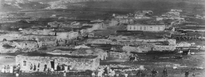
Armenian Karakala – photo © molokane.org

If one studies Merkezkarakale in satellite view at high magnification on the  Google Map, one thing that is noticeable and common to both photograph and satellite image is the village’s linear structure – essentially it is a single street with plots to the left and right set back at different short distances from the road. Although 100 or more years may have passed, and the village will have been rebuilt and extended, and perhaps shifted its centre of gravity, its basic plan seems remarkably similar today. The axis of the village is NW to SE. The road in the satellite view, extending off to the right half way down the village street (heading roughly N), looks like a more organic recent development. The old photograph seems to have been shot from an elevation and may have been taken on the rising ground SE of the village.

Merkezkarakale

Merkezkarakale today, orientated to match old village photograph 

This is the only village named Karakala with a linear settlement plan in the former Kars oblast.If one looks at each of them in turn at high magnification on the Google Map, it will be seen that all of the others are organic, sometimes seemingly random, clusters of low buildings. Merkezkarakale is the only one with the planned look and feel of a linear village. It has been suggested that Armenian Karakala was built shortly after the Russian administration arrived in 1878; if so, then this would be consonant with the appearance of a “modern” rectilinear and planned layout.

It is not clear whether there are any surviving genealogical records for Karakala; and, if so, where they are held; and whether they cover both the Armenian Apostolic and the village’s burgeoning Armenian Protestant or Evangelical sect known as the “Jumpers” which generated many of the emigrants to California. The 1908 Kars oblast gazetteer explicitly describes the village as Armenian Protestant, so we know that the correct place has been identified.

Among the surnames of the original immigrant Armenian families with roots in Karakala are Katanian, Keosababian, Mooshagian, Nalian, Perumian, Shaharian and Stepanian.

This blog and the accompanying maps first appeared on the bluebirdresearch website in 2010 and 2011.