The Birobidzhan Jewish Autonomous Oblast

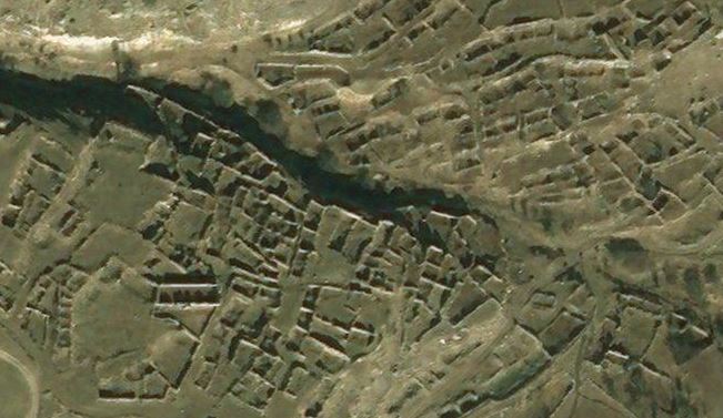
This Google Map shows the past and present Jewish settlements in Birobidzhan (also transliterated from the Russian as Birobidjan and Birobijan), the so-called Jewish Autonomous Oblast of Russia.

Birobidzhan was named after the Bira and the Bidzhan, the two main local tributaries of the Amur, which forms the southern border of the oblast and divides it from Manchuria in China. The region is very remote and was sparsely populated – before the move to settle Jews here in the late 1920s, there were only some Cossack villages and a small Korean population. Consolidating the border zone was one of the Soviets’ reasons behind encouraging immigration.

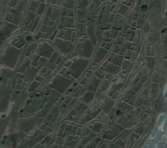
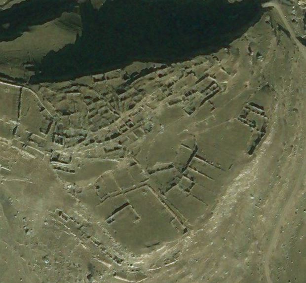
Birobidzhan was settled with some optimism and idealism in the late 1920s, although this may have been misplaced – the new settlements were overwhelmingly agricultural enterprises and many of the settlers were lacking in the necessary experience and skills and became urbanised instead. As a result, some of the early agricultural settlements such as Pompeyevka were abandoned over time. The riverside collective farm at Stalinsk (Stalinfeld) was abandoned for a different reason, due to severe flooding by the Amur in 1958.

The Jewish Autonomous Oblast suffered, like the rest of Russia, during the Soviet purges and in 1937-1940 (and later) many local Jews in Birobidzhan were arrested on usually fabricated charges and prosecuted and in some cases executed.

For example, looking at Stalinsk we find the following accused Jewish residents of the collective farm. Spellings of names are mostly a direct transliteration from the Russian (in which language the preference is to render proper nouns phonetically), so may differ from the normal spellings in the Latin alphabet. The Russian use of the otchestvo (patronymic) clearly helps in identifying an individual, so that e.g. Mordukh Abramovich Ekelchik is Mordukh Ekelchik, the son of Abram. The places of birth are given, anachronistically, to show the present-day location, and indicate how diverse the places of origins of these Jewish settlers were.

Mordukh Abramovich Ekelchik. Born in Minsk, Belarus in 1880. Farm produce distributor. Arrested 18 Oct 1937, shot 29 Jan 1938.

Khaim Yakovlevich Kab. Born in London, England in 1905. Tractor driver. Arrested 12 Dec 1938, case dismissed for want of evidence 29 May 1940.

Shimon Iosifovich Shef. Born in Zhytomyr, Ukraine in 1894. Loader on grain farm. Arrested 14 Oct 1937, sentenced to 10 years 31 Dec 1937.

Isaak Tevelevich Sukhoy. Born in Dubăsari, Moldova in 1899. Arrested 12 Mar 1938, sentenced to 6 years 21 Oct 1938.

Lev Yankelevich (or Yakovlevich) Zhak. Born in Ukmergė, Lithuania in 1901. Fire chief on grain farm. Arrested 3 Dec 1938.

And below are some of the Jewish victims from the small settlement of Smidovich:

Moses Fimelevich (or Fishelevich) Berezovsky. Born in Brest, Belarus in 1901. Russian Red Cross oficial. Arrested 20 Nov 1937, sentenced to 10 years 4 Jan 1938.

Moisza Abramovich Bykhovsky. Born in Panevėžys, Lithuania in 1915. Turner.  Arrested 28 Dec 1937, case dismissed 3 Apr 1939.

Henrietta Moiseevna Fiks. Born in Daugavpils, Latvia in 1908. State bank accountant. Arrested 11 Jul 1938, sentenced to 8 years 22 Oct 1938.

Israel Isaakovich Fishbein. Born in Uzda, Belarus in 1907. Secretary. Arrested 26 Oct 1937, case dismissed 13 Nov 1939.

Rakhil Ioselevna (or Moiseevna) Gamarskaya. Born in Vilnius, Lithuania in 1898. Instructor. Arrested 23 Nov 1937, sentenced to 5 years 27 Jul 1938.

Shaya Solomonovich (or Sholomovich) Gilinsky. Born in Poland in 1906. Agronomist. Arrested 7 Jul 1937, sentenced to 10 years 22 Oct 1938.

Khaim Peisakhovich (or Teisanovich) Kaplan. Born in Shchadryn (Shchedrin), Belarus in 1902. Party official. Arrested 3 Feb 1938, case dismissed 21 Mar 1938.

Bluma Isaakovna Meerbaum. Born in Romania in 1908. Jewish elementary school teacher. Arrested 15 Feb 1938, sentenced to 10 years 27 Jul 1938.

Zusman Ioselevich Perevozkin. Born in Vilnius, Lithuania in 1903. Chairman. Arrested 23 Nov 1937, convicted 18 Jul 1938, shot 16 Aug 1938 in Khabarovsk.

Sara Mikhailovna Shtern or Stern. Born in Ostroh, Ukraine in 1896. Party propagandist. Arrested 6 Jul 1938, case dismissed 16 Jan 1939.

Grigory Samoilovich Vasilevsky. Born in Moscow, Russia in 1913. Foreman of the collective farm. Arrested 10 Jan 1949, sentenced to 10 years 24 Dec 1949.

Shaya Srulevich Verkhivker. Born in Voznesensk, Ukraine in 1888. Official. Arrested 21 Oct 1937, sentenced to 15 years 11 Nov 1937.

Ilya Mikhailovich Zimmerman. Born in Chernovin (possibly Chernobyl intended?), Ukraine in 1904. Director. Arrested 31 Mar 1937,  convicted 17 Jul 1937, shot 17 July 1937 in Khabarovsk.

Despite increases in population into the 1940s, over time the Jewish population diminished through out-migration, a phenomenon which inevitably increased when the USSR dissolved and emigration beyond the Soviet Union became a possibility. Today, the only notable known Jewish centres of population are in the capital Birobidzhan and in the nearby village of Valdgeym. However, during the time of the USSR with its aggressively secular ethos, it is likely that there were mixed marriages and assimilation, so that mainly ostensibly Russian individuals in the oblast may have partly Jewish roots.


The Karaim

Back in May 2001, I visited the town of Trakai in Lithuania. A mini-bus took me and a handful of Japanese tourists the 30 or so km from Vilnius bus station and dropped us off outside Trakai’s tourist attraction, the restored Trakai Castle situated romantically in lake Galvė. While the others headed across the footbridge to the castle with their cameras at the ready, I wandered by myself the length of the little town to see what I could find of the Karaim.

Karaism is a non-Talmudic Mosaic faith and the Karaim, or Karaites, are a dispersed people with what are generally regarded as Semitic but sometimes, probably fancifully, as Turkic roots, living in scattered communities across the former Soviet bloc and the Middle East.

Historically in what is today Ukraine, Karaim lived in towns such as Lutsk (inter-War Polish Łuck) and Halych (after which the former Austro-Hungarian province of Galicia is named). There were many Karaite communities in the Crimea, in towns such as Bakhchisaray (Bağçasaray), Feodosiya (Kefe) and Yevpatoriya (Keslev). One of the best-known traditional centres of the Crimean Karaim was Chufut Kale (Çufut Qale) but this was abandoned during the 19th century (although two kenesas survive, adjacent to one another). The Crimean Karaim often lived by trade and therefore sometimes had mercantile links and family outposts in Black Sea ports (e.g. Kherson and Odessa) and the Eastern Mediterranean (e.g. Egypt and Constantinople).

The Karaim in Lithuania arrived at some date before the end of the C14th, almost certainly as officially invited and privileged settlers involved in defence. It is not clear whether the original settlers came from the Crimea or from Lutsk. In any event, while military service may have been the prime mover behind their arrival in Lithuania, soon many Karaim were involved simply in agriculture or in trade.

The most well-known settlement in Lithuania is that at Trakai which I visited but smaller communities survive in Panevėžys and Vilnius. There is a Karaim cemetery in each of these three places. The one in Trakai is disappearing amid meadow and woodland on the other side of lake Totoriškiai facing the town – inscriptions are mostly in Hebrew but with some Latin script. A Karaim place of worship – a prayer house known as a kenesa – survives at Trakai and Vilnius but that in Panevėžys was destroyed in 1970, a victim of the atheist communist state and probably also the declining local population and the ongoing process of assimilation. Other Lithuanian Karaim communities such as the one in Biržai have become extinct or, like that in Naujamiestis, all but died out with only individuals or solitary families surviving. The Lithuanian Karaim population is now very small and dwindling: officially 423 in 1959, 388 in 1970, 289 in 1989 and 273 in 2001. Assimilation and out-marriage are serious issues for the survival of the community, which traditionally was endogamous and sometimes had to resort to sourcing marriage partners from Lutsk or even the Crimea.

A distinctive feature of the Trakai Karaim settlement is its vernacular architecture. The typical Karaim wooden cottage, sometimes painted in pastel or brighter shades, sits with its gable end with three ground-floor windows facing on to the street; the entrance is on the facade round the side.

One reason why the Lithuania Karaim community survives at all today is the official recognition they gained in 1863. In that year, they successfully asserted themselves as a Turkic people in contra-distinction to the Jews, with whom they had previously been associated in the Russian Empire. The unforeseen consequence of this was that they were largely spared the fate of the Lithuanian Jews during the Holocaust.

The Google Map shows the distribution of past and present Karaim settlements from Lithuania in the north, south through Poland and Ukraine to Crimea, and on to Egypt, Turkey and Israel. The pattern is quite curious, with a north-south axis, especially noticeable if the newer, post-WW2 diaspora Karaite communities, such as most of those within the borders of modern Poland, are disregarded. Green Stars of David pins show kenesas/synagogues, both surviving and former. Blue pins show cemeteries and settlements which have or may still have a Karaite population, no matter how small. Grey pins show extinct settlements.


יהדות_קראית

The Digor Ossetians

This Google Map focuses on the Digors, Ossetians speaking the Digor (as opposed to the dominant Iron) language of North Ossetia. Under the influence of their western neighbours the Kabardians, many Digors converted, from either their traditional animist religion or from Eastern Orthodoxy, to Sunni Islam. It was this conversion which led to their oppression. The expansion of the Russian Empire into the Caucasus and the ensuing Caucasian War culminated in many Muslim peoples of the North Caucasus being ethnically cleansed and fleeing to the Ottoman Empire as muhajirs (emigrants, refugees) in the 1860s. Digor Ossetians were among them. During and immediately after WW2 (known to the Russians as the Great Patriotic War), Digors were one ethnos among many deported en masse by the Soviets to Kazakhstan. The majority, albeit not all, of the groups deported from the North Caucasus were Muslim (exceptions included the Black Sea Greeks).

The map shows past and present settlements of the Digors, both in North Ossetia (blue pins) and in Turkey (red pins). I should stress that the settlements shown in Turkey are believed to be Digor (rather than Iron) Ossetians, as it was the Digors rather than the Irons who converted to Sunni Islam and therefore were minded to seek refuge in or emigrate to Sunni Turkey in the 1860s. However, it is possible that some of the Ossetian communities in Turkey shown on the Google Map were in fact settled by Iron converts to Islam among the muhajirs from the North Caucasus; therefore, caveat emptor.

In the Digors’ traditional North Ossetian homeland, former settlements abandoned and destroyed are shown by the circular blue markers with the white x. In the pin texts, these are described as villages but most were very small settlements and some were inhabited by a single extended family.

The exact location of the abandoned settlements is not always clear. In some cases, satellite imagery shows clearly the outline of buildings (surviving stonework etc), presumably of villages abandoned in the C20th. In other cases, there is no immediately obvious trace at the available map coordinates, while in others the current sateliite imagery (as at January 2018) does not permit any inspection due to thick cloud cover.

Please note that the map excludes the cities to which Digors have moved as economic migrants – for example, Moscow and St Petersburg in Russia and Ankara, Istanbul and Sivas in Turkey. Digors also reside in diaspora in, for example, Kazakhstan (descendants of the deportees who have not returned) and Syria.


Return to Lithuania, 1921

In eastern Europe, the aftermath of the First World War and the Russian Revolution was chaos and population displacement on a previously unknown scale. Imperial Russia unravelled around the edges and new states struggled to assert their independence and pull away. In the former Russian gubernias of Kovno, Vilna and Grodno, moves were afoot to recreate Lithuania.

However, the issue here, as elsewhere in Europe, was that there were competing and mutually incompatible claims to land. It was impossible to satisfy all claims, as the population was not neatly parcelled up into ethnically or nationally homogeneous units. Most regions had diverse populations. In the city today called Vilnius, for example, Poles and Jews formed the majority and in its hinterland many of the pre-War landowners were minor Polish gentry or szlachta; yet the peasantry was Lithuanian. Force decided the issue and treaties ratified it. It was the new Polish state which emerged victorious, securing a Polish Wilno, just as it successfully secured Lwów as a Polish island in a largely Ukrainian sea.

At the start of 1918, as many as one in six Lithuanians were refugees within Russia. An estimated 550,000 were scattered across European Russia, from Minsk and St Petersburg to distant Voronezh and Yekaterinoslav. It took until 1924 to bring home all those who wanted to return and who Moscow and Kaunas would between them allow. Maybe as many as one third of Lithuanian refugees remained abroad and settled, willingly or otherwise, in Soviet Russia or Poland.

From 1921, the return of refugees was closely supervised by the authorities. Refugees were registered and issued with travel permits in Moscow. From Moscow they travelled by train to Rēzekne, Daugavpils and Kalkūni in Latvia, and thence across the Lithuanian border to Obeliai. At Obeliai – the only recognised point of entry into the country, although not the only one in practice – refugees were vetted, re-registered and issued with passes, usually to their place of birth or pre-War residence.

Those who were regarded as suspect were sent back to Moscow. And those refugees who wished to return to their pre-War homes in what had become Polish territory were often stuck in limbo for months on end in the Obeliai transfer camp, with its ever-present risk of humanitarian crisis – typhus, cholera and hunger.

Not all those coming to Lithuania were refugees. So-called optants – Lithuanian colonists long settled in Russia – paid their own way to reach the newly independent country. And from 1918 to 1921, the nascent Lithuanian state, in need of qualified administrative and technical experts, welcomed back not just its Lithuanian but also its Jewish middle classes. In fact, the immigration policy was so liberal before the change of government in 1922 that Jewish doctors, engineers and so on from elsewhere in Russia headed to Lithuania for the opportunities it presented.

For many researching their family history in Lithuania, the period 1915 to 1924 looms like something of a black hole. For a start, the family may not appear in the expected parish registers (assuming, that is, that such records were created and have survived). Over half a million spent several years effectively in exile in Russia and, of course, of these, some married, some had children and some died there. At Obeliai, too, refugees gave birth or died and, doubtless, in some cases married. The Lithuanian state did not recognise Soviet civil registry marriages so, in order to return with spouse and children, natives of Lithuania would have to remarry in a Roman Catholic or Orthodox ceremony: this can result in what appear to be illegitimate children born between the respective dates of the secular and the religious marriage.

The Google Map shows the railway route from Moscow’s Vindavsky Station to the transfer camp at Obeliai.


Upper Balkaria

If you zoom in to Verkhnyaya Balkariya using satellite imagery on Google Maps or Bing, you notice, like a palimpsest, the history of past settlement around the modern planned town with its regular and rectilinear grid-like layout. As at the time of writing (January 2018), the Microsoft satellite imagery used by Bing is clearer than Google’s as it was taken in good light. Below are screenshots showing five of the vanished villages and hamlets of Upper Balkaria.

Glashevo:

Glashevo

Kospart:

Kospart

Kyunlyum:

Kyunlyum

Mukush:

Mukush

Sauty:

Sauty

The accompanying Google Map shows the main villages (blue pins) and various hamlets and neighbourhoods (grey pins) of this part of the Cherek river valley in Upper Balkaria. Until Nov-Dec 1942, these were entirely populated by Balkars, a Turkic and Muslim people of the north Caucasus. At that date, these Balkar villages were razed and the population decimated – men, women and children were brutally killed by the Red Army on the orders of the NKVD. As you can see from the images above, the villages were completely destroyed and only a ruined archaeology remains.

In March 1944 the balance of the inhabitants of Upper Balkaria, together with all other Balkarians (37,103 in total, according to NKVD head Lavrentiy Pavlovich Beria’s official report), was deported en masse to Central Asia (mostly the Kazakh and Kyrghyz Soviet Socialist Republics). There they remained in exile until a decree of March 1957 permitted the survivors to return to their homeland.

According to the 2010 census, Balkars make up  12.7% of the population of the Russian Republic of Kabardino-Balkaria (being outnumbered by the indigenous Kabarday, who comprise 57%, but also by ethnic Russians, who make up 22%).


Armenians in Turkmenistan

The Google Map shows known Armenian communities in the Central Asian Republic of Turkmenistan. This corrupt and repressive state was ruled by the vainglorious dictator Saparmurat Niyazov from the break-up of the Soviet Union until his death in 2005 and since then by another narcissistic autocrat, Gurbanguly Berdimuhamedow.

There are perhaps 30 to 40,000 Armenians in the country, living mostly in the major cities indicated on the map. Armenians arrived in Turkmenistan during Imperial Russian times, others during the Soviet era. More recently, more arrived following the dissolution of the Soviet Union and the conflict between Armenia and Azerbaijan. Minorities have limited rights in Turkmenistan and, as might be expected, many Armenians with the means to do so have emigrated to Armenia, Russia or USA in recent years .

There is no registered Armenian place of worship in Turkmenistan. The state recognises only Islam and the Russian Orthodox Church (the churches of which are used by some Armenians).

Of the five pre-Soviet-era Armenian churches (one per city shown on the map, except Balkanabat), the last standing was the one in Türkmenbaşy (Turkmenbashi – Russian Krasnovodsk), which was demolished in 2005. The former Armenian Apostolic church here was founded in 1904 but seized by the militantly atheist Soviet authorities in the 1920s and used as a warehouse. According to accounts on the internet, the church stood, decommissioned, at the junction of Pushkin and Lermontov streets. Street names in Türkmenbaşy have, for the most part, been renamed, although the street name Puşkin Köçesi survives in the old town (which was primarily Russian). However, Soviet-era Russian language maps do not show Ulitsa Pushkina and Ulitsa Lermontova as intersecting. Ulitsa Pushkina street was a short road joining Ulitsa Gogolya and Ulitsa Budennogo, both of which ran down to the square Ploshchad Privokzalnaya and the railway station by the waterfront. Ulitsa Lermontova, on the other hand, was further north, beyond the Russian cemetery (in which Armenians were presumably buried, it being the only Christian burial ground in the city) and running off 1 Maya (now Azadi Köçesi). Perhaps, therefore, Gogol rather than Lermontov was meant. Accordingly, the pin on the Google Map has been placed where the former Ulitsa Gogolya (now called Adalat Köçesi) joins Ulitsa Pushkina. In any event, the church survived until 2005, when it was demolished by the Turkmen authorities, despite repeated requests for it to be returned to the Armenian community.

The Krasnovodsk street plan below shows the old Russian town, with Russian street names, during Soviet times. Ulitsa Pushkina can be seen (as “ул. Пушкина”) towards the left-hand side of the map.


Krasnovodsk


The Terek Kumyks

The Google Map shows the main locations of the Terek Kumyks in modern times.

Settlements in Chechnya are shown with green pins, those in Ingushetia are marked with red pins, and those in North Osseta-Alania with blue pins.

Germenchuk and Shali, in Chechnya, which lie away from the Terek river, are thought to be two of the sources of the Terek settlements. A few hundred Kumyks still reside in the town of Shali but Germenchuk now has an entirely Chechen population.

Kumyk place names are shown in brackets after the official (modern) Russian place names. For example, Predgornoye is known to Kumyks as Borasuv-otar.


The Udi

The Google Map shows the distribution of the Udi, an ancient relict ethnos of the Caucasus, the survivors of the formerly great Caucasian Albanian people.

Today, this Christian people is found primarily in two large villages in Azerbaijan (Nic and Oğuz, known until 1991 as Vartashen) and one small settlement in Georgia (Zinobiani). There are smaller numbers of Udi in a few other villages in Azerbaijan (and of course in its capital Baku) but most have assimilated or left the country for Armenia and, more especially, Russia. Most of the settlements in Azerbaijan marked with blue pins on the map therefore effectively show former rather than extant Udi communities.

As mentioned, there are numbers of Udi in diaspora dispersed across both cities and villages in southern Russia (shown with grey pins on the map) and elsewhere across Russia (not marked on the map).

Finally, there are also about 200 Udi refugees from Oğuz in a handful of villages in Armenia; these are marked with red pins.


The Tsakhur of Dagestan & Azerbaijan

The Google Map shows the main areas of settlement of the Tsakhurs. The Tsakhur are a northern Caucasian people or ethnos with their own Tsakhur language (one of the Lezgic family of languages in the NE Caucasus). The Tsakhurs will, of course, additionally speak the majority language, such as Azerbaijani or Russian, where they live. They profess Sunni Islam.

The Tsakhur territory was centred originally on a highland valley (that of the river Samur) in what is now the SW of the Republic of Dagestan in Russia. This is shown on the map by the line of 13 auls marked with blue pins. However, there was an expansion of territory over the mountains, extending it into what is now Azerbaijan, in the C15th – shown with green pins. The two capitals, as it were, were respectively Tsakhur aul itself in Dagestan, and İlisu village in Azerbaijan.

Place names on the Google Map are given in a standardised transliteration from the Russian for Dagestan, and in a modified Azerbaijani (using an ä instead of a schwa) for those in Azerbaijan. In some cases, alternative spellings or names are given in brackets.

One interesting place is Baş Suvagil, on the banks of the Qaraçay, which was flooded repeatedly, leading its inhabitants to establish a new Yeni Suvagil at a safer spot down on the plains. Satellite imagery suggests that people have again settled the site of Baş Suvagil.

The map also shows more recent dispersal by the Tsakhurs to the big cities of Dagestan and to a belt of Soviet era farming villages in the NE of the Republic.


The Mamkhegh of Adygea

The Google Map shows only a little of the history of the Mamkhegh. The Mamkhegh are a Circassian people and specifically one of the 12 Adyghe tribes, with their own eponymous dialect. They are Sunni Muslim.

Their historic villages were situated to the south of the town of Maykop. The approximate sites of the 12 largest of these are shown with blue question marks on the map. The exact sites are not certain but the distribution and spatial inter-relationship of them on the map is reasonably correct – or, at least, it follows the rough sketch map drawn up by local ethnographer Aleksandr Nikolayevich Dyachkov-Tarasov in 1901. Dyachkov-Tarasov uses the traditional Circassian and Caucasian word “aul” for each village and shows the borders of the Mamkhegh territory stretching south of Maykop in a dewdrop shape between Dagestanskaya and Abadzekhskaya villages on the rivers Kurdzhips and Belaya respectively.

These native villages were depopulated towards the end of the Caucasian War, circa 1862-63. At that time, most Mamkheghs, along with other Muslim Circassians, were deported from the Russian to the Ottoman Empire – presumably, their descendants live somewhere in Anatolia now. Those Mamkhegs who remained within Adygea were settled in the new eponymous village of Mamkheg and the other villages shown in yellow on the map.